Back نهر دوناچيك ARZ Дунаец Byelorussian Дунаец Bulgarian Dunajec Catalan Dunajec CEB Dunajec Czech Dunajec Danish Dunajec German Ντουνάγιετς Greek Dunajec Esperanto
| Dunajec | |
|---|---|
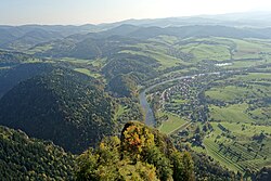
 Dunajec viewed from Trzy Korony | |
| Location | |
| Country | Slovakia, Poland |
| Physical characteristics | |
| Mouth | |
• location | Vistula |
• coordinates | 50°14′35″N 20°43′42″E / 50.2431°N 20.7283°E |
| Length | 249 km (155 mi) |
| Basin size | 6,796 km2 (2,624 sq mi) |
| Discharge | |
| • average | 85.5 m3/s (3,020 cu ft/s) |
| Basin features | |
| Progression | Vistula→ Baltic Sea |
The Dunajec (Polish pronunciation: [duˈnajɛt͡s]; Goral dialects: Dónajec; Slovak pronunciation: [ˈdunajet͡s]) is a river running through northeastern Slovakia and southern Poland. It is also regarded as the main river of the Goral Lands. It is a right tributary of the Vistula River. It begins in Nowy Targ at the junction of two short mountain rivers, Czarny Dunajec and Biały Dunajec (Black and White Dunajec). Dunajec forms the border between Poland and Slovakia for 17 kilometres (11 mi)[1] in the Pieniny Środkowe (Slovak: Centrálne Pieniny) range, east of the Czorsztyn reservoir.
© MMXXIII Rich X Search. We shall prevail. All rights reserved. Rich X Search